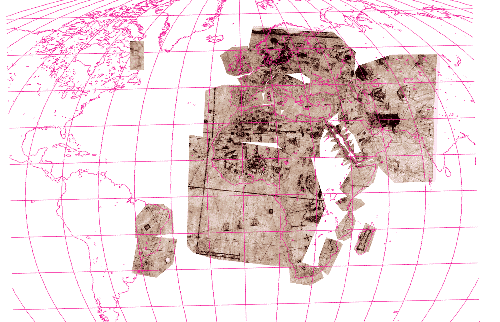
The pink outlines are a present-day elliptical projection from the Xerox Think Tank. This service is unfortunately no longer available.
The brown portions are from a 1516 nautical chart in the Huntington Library
|
|
|
|
This virtual cut-and-paste shows how the master charts
were constructed..Until the nineteenth century maps and
charts were pieced together by master-mapmakers using
information gathered from different individuals or
expeditions. Each brown piece represents information
gathered on a separate voyages. On the coast of Brazil there
are two separate sections--most likely from the two separate
Gonzalo Coelho expeditions. And the three separate pieces
from Mossel Bay (South Africa) to north of Mozambique are in
all probablity the three missing voyages between Bartholomew
Dias 's first voyage (1487) and Vasco da Gama. (1497). (For
more on the navigational difficulties of this area, find out
about the Agulhas current.) |