![]()
Ocean Currents and Tides: The Treacherous
Agulhas
![]()
|
|
|
|
In nearly a thousand years of crossing the Indian Ocean, neither the Arabs nor Persians nor Arabs nor the fifteenth-century Chinese Star Fleet had ever navigated the Mozambique channel south of Sofala, even though they were sailing with the the Agulhas Current.
In order to sail around the tip of Africa, Portuguese sailors had to move against two powerful ocean flows: the Agulhas and Benguela currents.*
The second swiftest current in all the world's oceans, the Agulhas is deadlier than the swiftest current (the Gulf Stream) because the Gulf Stream moves through open waters of the Atlantic. But the Agulhas travels swiftly between two bodies of land--Madagascar and Mozambique (downward arrow on map). Furthermore its waters flow in the opposite direction from which Portuguese ships needed to travel.

How Portuguese Ships Sailed:
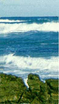
To sail north against the Agulhas Current is far tricker than sailing with it. Portuguese boats had to tack back and forth in a narrow band of water between the Agulhas current and the shore. For part of that journey submerged sharp rocks abound and modern shipping trawlers with sophisticated navigational instruments still wreck today.The picture on the right shows the rocky coast of South Africa today with the Agulhas current just beyond.
Additional Dangers:
Gale Force Winds (up to 180 kilometers per hour) accompany cyclones which are common in the Spring (September through November).Rogue Waves Even more frightening are the deadly changes that occur when the winds shift direction. When the winds begin to blow from the West and Southwest (the opposite direction from the current), monster waves (up to five stories high) are known to occur. There is no way to survive such rogue wages, for even the largest vessels plummet to the ocean floor without a trace.
Bathymetry and relief map of Atlantic
and
Western Indian Ocean adapted from NOAA
*The warm Agulhas runs south and west from the Indian Ocean until it reaches the near-freezing waters of Antarctica, which force it into swirls around the southern tip of Africa The icy Benguela rushes north from the Southern Ocean around Antarctica along South Africa's western coast.
Why is it called Agulhas? | The Benguela Current| | Home page
Elsewhere on the NetA Primer on Ocean Currents | Tides: An Introduction | Classic Images of the Aguhas Current | The US Navy on Waves