Beginning in the 1440s, Portuguese ships ventured further
and further into the Atlantic and down the Southern coast of
Africa., first accumulating knowledge of the South Atlantic (by
1487), then the Mozambique channel (by 1497) and by 1502 Brazil
and Canada (the New World).
- After every expedition, map-makers for Portuguese kings
incorporated information from the most recent voyages of
exploration.
- By 1492, Portuguese cartographers were creating
enormous master charts containing all the latest
knowledge of coastlines, and oceans.
- These master charts were regarded as state
secrets. Furthermore, many were destroyed by Europe's only tsunami in 2,000 years which hit Lisbon in November 1755.
- As a result few Portuguese originals (such as
Jorge Reinel's) have survived. Most of charts known today
are pirated copies collected by jealous Italian
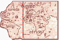
competitors including the Cantino (1502) map, the Caverio map (1505),
and the Maggiolo (1516) map shown below.
- The master charts were based on
separate local nautical charts.
- By 1505 and probably earlier as well, each of the major
Atlantic ports also had a separate approach chart detailing
soundings, dangers, and other information needed to guide
sailors safely into port. (Sea and airline pilots today use
separate approach charts for each sea and airport.)
|