Volcano Images Page
compiled by
Bill Leeman
Rice University
click on underlined links for more info
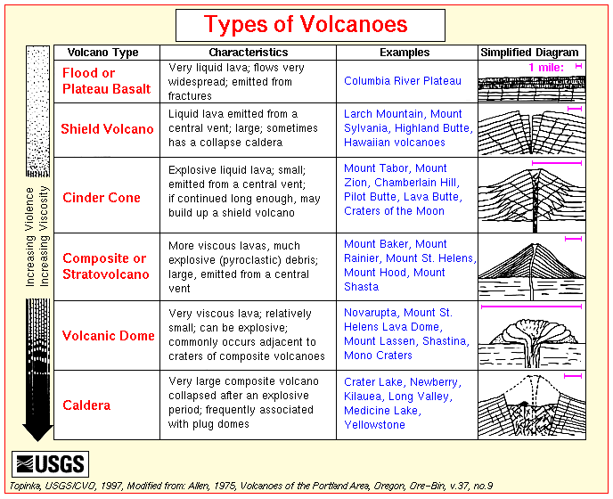
Volcano Classifications
Types
of volcanoes
Cinder
cones
Composite
or stratovolcanoes
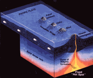
Shield
volcanoes
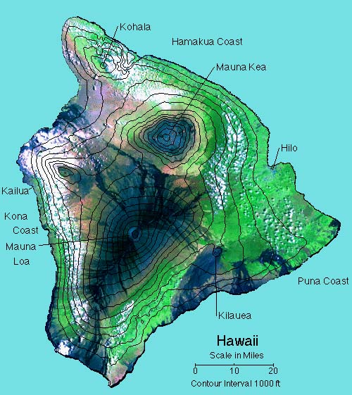
- Mauna
Loa Shield Volcano, Hawaii, as seen
from Mauna Kea summit -- Photo by Tom Casadevall, May 9,
1979.
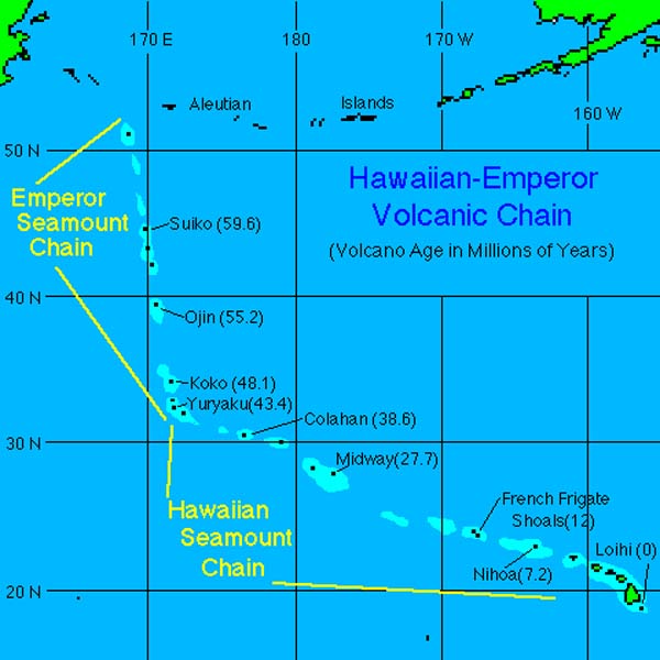
- Island
of Hawaii, comprising 5 shield
volcanoes
- Iceland examples
- 1973 Eldfell eruptions, Heimaey
- 1783-85 Laki fissure eruptions
- Aerial view Mount
Bachelor, Oregon, as seen from Sparks
Lake area -- Photo by Lyn Topinka, 1985
- more on shield volcanoes
Large
Igneous Provinces (LIPs)
Submarine volcanoes
Calderas
Other Volcano Photo Archives
Types
of Eruptions
(Table)
Non-explosive:
- Flood lavas - basaltic, can be highly
voluminous - Iceland, Columbia River Plateau and other flood
basalt provinces, lunar mare (cf. large igneous provinces or
'LIPs')
- Hawaiian style - similar to flood type, but
with some tephra and fast-moving fluid
lavas, often channelized; these tend to
form large shield-like cones
- Mid-ocean ridges (e.g., Juan de Fuca Ridge) -
largely restricted to spreading center rifts as small cones and
sheet flows
- Style
of lava flows can vary with
temperature, gas content, etc.
Explosive (in order of increasing
energetics):
- Strombolian - bombs, molten ejecta, lavas --> symmetrical scoria
cones, mafic compositions
- Vulcanian - ejecta blocks, pasty silicic lavas --> scoria
cones & stratovolcanoes of tephra layers and ejecta deposits
- Surtseyan - hydrovolcanic, magma and water mixtures --> large
clouds of fine pyroclastic dust, near-vent rings of coarser ejecta
- Vesuvian/Plinian - very explosive, wide distribution of tephra, can lead
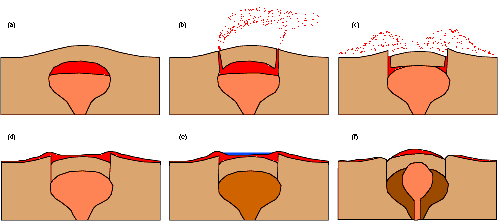
to caldera collapse in large stratovolcanoes (Vesuvius, Pinatubo)
- Peleean -
collapse of ash columns --> pyroclastic flows (nuees ardentes),
debris avalanche deposits or ignimbrites (Mt. Pelee, Martinique)
- Bandaian -
lateral explosion --> cyclone-like (up to 150 km/hr) base surge
deposits (Mount
St. Helens)
Volcano Morphology
- Volcano forms and processes are directly
related to physical properties, compositions, and volumes
(eruptive rates) of magmas, which in turn influence style of
eruption.
Volcanic Deposits
Debris Avalanches
Debris flow movie
- Aerial view of Mount
Adams and the August 31, 1997 debris
avalanche. -- Photo by R. Iverson, September 8, 1997
- Debris-flow
avalanche deposit from Mount St. Helens
formed on 18 May 1980. Hummocky surface is typical of avalanche
deposits.
- This photograph shows a large
dacitic block from Mount St. Helens
within a matrix of smaller sized and more mafic composition
fragments. Erosion has carved into the debris avalanche to provide
exposures of individual blocks. Although the blocks are coherent
masses, they have been extensively fractured and can be excavated
with a shovel. Dr. Eric Baer for scale (arrow).
- This downstream view of the North Fork
Toutle
River valley, north and west of St.
Helens, shows part of the nearly 2/3 cubic miles (2.3 cubic
kilometers) of debris avalanche that slid from the volcano on May
18. This is enough material to cover Washington, D.C. to a depth
of 14 feet (4 meters). The avalanche traveled approximately 15
miles (24 kilometers) downstream at a velocity exceeding 150 miles
per hour (240 km/hr). It left behind a hummocky deposit with an
average thickness of 150 feet (45 m) and a maximum thicknes of 600
feet (180 meters). -- Photo by Lyn Topinka, November 30, 1983
- Mount
Shasta and debris avalanche hummocks.
-- September 22, 1982, by Harry Glicken
- Maps of deposits
Blow-down
- The slopes of Smith
Creek valley, east of Mount St. Helens,
show trees blown down by the lateral blast. Two U.S. Geological
Survey scientists (lower right) give scale. The direction of the
blast, shown here from left to right, is apparent in the alignment
of the downed trees. Over four billion board feet of usable
timber, enough to build 150,000 homes, was damaged or destroyed.
-- Photo by Lyn Topinka, September 24, 1980
Debris flows, mudflows, lahars
Lahar movie
- Photographs
- An explosive eruption at Mount
St. Helens on March 19, 1982, sent
pumice and ash 9 miles (14 kilometers) into the air, and
resulted in a lahar (the dark deposit on the snow) flowing from
the crater into the North Fork Toutle River valley. Part of the
lahar entered Spirit Lake (lower left corner) but most of the
flow went west down the Toutle River, eventually reaching the
Cowlitz River, 50 miles (80 kilometers) downstream. -- Photo by
Thomas J. Casadevall, March 21, 1982
- Debris flow aftermath at Tahoma
Creek, Mt. Ranier, October 1, 1987.
-- Photo by Lyn Topinka, October 1, 1987
- Mount Adams as viewed from Harrys Ridge,
near Mount
St. Helens, Washington. Lake in the
foreground is Spirit Lake. -- Photo by Lyn Topinka, September
29, 1988
- Aerial view, Spirit
Lake and Mount St. Helens, from the
north, showing debris-avalanche-dam impounding the lake. --
Photo by Lyn Topinka, April 25, 1991
- Examples:
Lava domes
Lava flows
Lava flow movie
- Aerial view, Pu'u
O'o vent and pahoehoe lava flows,
east
rift zone, Kilauea, Hawaii. -- Photo by Lyn Topinka, USGS/CVO, April 14,
1986
- Newberry
Caldera showing Paulina and East Lakes,
and Big
Obsidian Flow (rhyolite). -- Photo by
Lyn Topinka, August 20, 1985
- other
examples
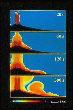
Pyroclastic
Flows
Pyroclastic flow movie
- One of the earliest photographs of a
nuée ardente. Photograph taken at Mont
Pelée, Martinique, on 16
December 1902 by A. Lacroix.
- Pyroclastic flow, August, 1986, flowing down
valley from Augustine
volcano, Alaska. Photo by Maurice and
Katia Krafft.
- Quarry within pyroclastic
deposits of Laacher See volcano,
Germany. Pyroclastic flow deposits are the thick, massive beds.
The pyroclastic surge deposits are the duned and cross bedded
deposits. Field study with Professor Hans-Ulrich Schmincke and
students in 1980.
- Examples: 1470 B.C. Santorini, 1815 Tambora, 1902 Mt.
Pelee, 1982 El
Chichon; 1991 Pinatubo
- Pyroclastic
Flow effects, examples:
- Animation of pyroclastic flow
- Model simulation for Vesuvius Plinian eruption (from Vesuvius
Home Page)
Maar or hydrovolcanic deposits
- Cerro
Colorado volcano, Pinacate Volcanic
Field, northern Mexico is a maar volcano with a broad crater and
low rims formed by hydrovolcanic processes. Prevailing winds blew
toward the southwest at the time of eruption to form the high
point of the rim.
- Rim
beds inside maar crater, Ukinrek
volcano, Alaska. Arrow points to Dr. Michael Ort, Northern Arizona
University, rappeling down crater wall to investigate origin of
beds. Dr. Wendell Duffield of the U.S. Geological Survey is on the
crater rim holding the rope.
- Grímsvötn
volcano erupted on September 30, 1996
underneath the extensive Vatnajökull glacier, Iceland. Such
explosive
eruptions resulted in catastrophic
flooding (a jökulhlaup event) due to melting of glacial
ice.
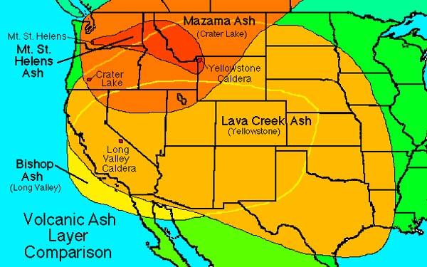
Ash-fall deposits
Ash fall movie
- Eruption of Anak Krakatau, Indonesia, September, 1979, sending
ash into the atmosphere. Photograph by Maurice and Katia
Krafft.
- Ash
fall on hut 3 km from rim of Pinatubo
volcano, Philippines, after the major 1991 eruption. Photograph by
R. P. Hobblitt, U.S. Geological Survey.
- Pre-historic ash
fall layers that blanket earlier
topography. Oshima Island, Japan. Photograph by R.V.
Fisher.
Complex volcanoes
Scales of impact
Distances covered
- Lavas - up to >100 km (depending on magma
type, viscosity, volume ejected, topography, etc.) glowing
avalanches (nuees ardentes) - up to >50 km (roughly 10-20 *
height of volcano)
- Ash/tephra - 100s to 1000s of km (depending on volume of ejecta
and column height [proportional to thermal energy released], wind
velocity and distribution). These factors govern the thickness
of tephra deposits as a function of distance from vent,
- Volcanic projectiles (stones, bombs) - up to
50-100 km (depending on muzzle velocity, size and density of
particles, ejection angle, etc.)
- Mudflows/lahars - up to 300 km (Cotopaxi
volcano)
Areas covered per eruptive phase
- Flood basalt eruptions - more than 10,000
km2 (but
commonly 10s -100s); 1783 Laki eruptions covered 565
km2
- Glowing avalanches - up to 100s
km2 (1902
Mt. Pelee, >80 km2)
- Ignimbrites (ash flow tuffs) - up to 1000s
km2 (cf.
U.S. examples)
- Lahars (up to 1000s km2)
Volumes extruded
Volcanic Explosive Index [VEI] -
roughly tenfold increase in ejecta volume (and energy release) for
each VEI-step; applied to explosive or pyroclastic volcanoes. Certain
types of eruptions (e.g., flood basalts, ignimbrite flows) are not
included. A comparison
in scale between shield (Mauna Loa) and
stratovolcanoes (Rainier) is illuminating. Also, time-history of
eruptive activity is highly variable between volcanoes - some
deposits accumulated over significant time periods (years, Mazama)
whereas others were formed in days (Krakatoa).
|
VEI rank
|
Volume (km3)
|
Historic examples
|
|
0
|
only fumaroles
|
1949 Yakeyama
|
|
I
|
<0.00001
|
1926 Tokachidake
|
|
II
|
<0.0001
|
1893 Asama
|
|
III
|
<0.001
|
|
|
IV
|
<0.01
|
1959 Oshima
|
|
V
|
<0.1
|
many Hawaiian eruptions
|
|
VI
|
<1
|
1980 Mt. St. Helens (0.5
km3)
|
|
VII
|
<10
|
1888 Bandai (1.2 km3)
|
|
VIII
|
<100
|
1883 Krakatau, 18 km3; 1470 B.C.
Santorini, 30 km3; Mazama, >40
km3
|
|
IX
|
>100
|
1815 Tambora, 150 km3
|
Maximum volumes for a single event generally
increase with silica content and vent size - up to 100s - 1000s
km3 for
large caldera-related silicic eruptions; can be significant for large
basalt eruptions.
Caldera sizes - range up to 100 x 35 km (Toba), 70
x 40 km (Yellowstone). There is a complete spectrum to smaller sizes.
Number of examples decreases with increasing size.
Volcanic Hazards
Current volcanic activity
Deaths associated with eruption types
Hazard
assessment
Additional resources
This page updated 12 Feb 2001 by
Bill Leeman