|
| The Portuguese planted giant navigational beacons ("padrões") on the coasts where no previous navigators had been. Each beacon corresponded to a precise latitude so pilots could check their coordinates when they saw the beacon from the sea off the coast. | |
 Artist's drawing of a navigational beacon at the Congo River. |
The top beacon is at the Congo River, the bottom at the Cape of Good Hope. |
| Unlike eighteenth- and nineteenth-century lighthouses the beacons did not have a light nor did they warn of danger. Instead they were navigational beacons indicating latitude. However in southern Africa many present day lighthouses are located where these padrões used to be. | |
Available Elsewhere on the Net |
| Modern
Lighthouses The World Over | Pictures
of US Lighthouses | Buoys
| U.S.
Coast Guard's Guide to the History of Lighthouses |
![]()
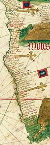 Artist's 1502 drawing showing where the beacons were placed along the West Coast of Africa.