The Beginnings of Open Ocean Travel across the Mid-Atlantic

Using charts like this in the 1440s the Portuguese became Europe's first regular open-ocean sailors, traveling to the Azores for more than a week without sighting land.


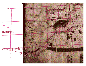
This 1440 chart has the approximately correct longitude of the Mediterranean. The Iberian Muslim astronomer Az-Zarqali (Azarquiel) correctly determined the longitudinal extent of the Mediterranean in the 11th century AD. Thus the Canary Islands show up exactly where they should be.

But why does the chart show the Azores in the wrong place?

a) Were the chart makers trying to hide the distance from sailors who might be fearful of the open ocean? Might chart makers have been trying to mislead the ordinary sailors on board?

b) Or was the reason more prosaic? Did they just run out of paper, or not want to waste paper drawing a vast expanse of ocean?


Before 1300, European navigators sailed at most a day (in the Mediterranean) or two (from Iceland to Greenland) away from the sight of land.

Az-Zarqali (who died circa 1100) corrected Ptolemy's estimate of the length of the Mediterranean sea from 62 degrees to approximately correct value of 42 degrees. He also anticipated Kepler by arguing correctly that the orbits of the planets are not circular but egg-shaped. Iberian astronomy was the most advanced in Europe.

What is the size of the earth? | More about this chart | A slow loading look at this chart | Home page