![]()
The First Prime Meridian on a Nautical Map
The First Prime Meridian on a Nautical Map
![]()
|
|
The First Prime Meridian on a Nautical Map |
A prime meridian is the place where to start measuring east-west distance. While the equator can only be in one place, the prime meridian can be anywhere you chose. |
|
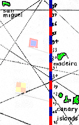
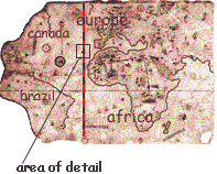
| The first country to create world sailing charts (Portugal) put the starting point in its territory (Madeira Islands-indicated by the red-and-blue-flag). |
|
Close-up of prime meridian , with alternating blue and red colors for individual latitude degrees. |
Location of prime meridian
|
History of Prime Meridians on Sailing Charts:
*While waiting to someone to invent a sufficiently accurate clock, the Portuguese devised a series of highly accurate approximations including the lunar distance model and the path of the solar eclipse. |