
Review of Global Seismicity & Earthquakes
Summary of basic terms and concepts
William P. Leeman/Rice University
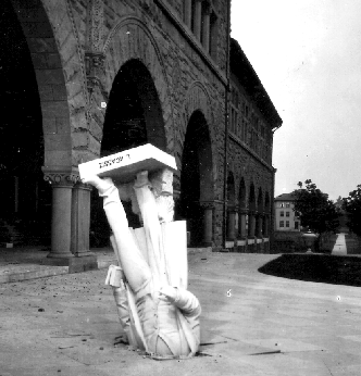
Statue of Louis Agassiz on Stanford campus following the 1906 San Francisco earthquake
Introduction
Tectonic forces within the Earth produce local accumulations of strain that may be released abruptly in the form of seismic energy. Earthquakes result from rapid release of stored elastic strain in the lithosphere, usually in the form of sudden movement of portions of the Earth's crust along faults. Comprehensive earthquake information, definitions, and examples are available at several WWW sites - some outstanding ones are listed below. This page is intended to provide a quick overview and links to particularly useful WWW resources.
Background information
To understand seismicity it is important to consider the physical state of rocks in the solid Earth.
Changes in the physical properties of rocks with increasing temperature and pressure (i.e., increasing depth in the Earth) result in decreasing viscosity (a parameter that measures 'resistance to flow') and a transition from 'brittle' to 'ductile' deformation. That is, the outer part of the Earth deforms mainly by fracture, whereas rocks in the deep crust and mantle undergo plastic flow or creep over geologic time scales. The outer (ca. 50-100 km ) layer of the Earth behaves as more or less rigid 'plates' (lithosphere) that can 'drift' on the deeper, less viscous interior (mantle) that is undergoing slow convection.
The boundary between lithosphere and mantle is believed to reflect the change in rheology which is temperature sensitive. Thus, it is a thermal boundary layer (ca. 1300°C isotherm). It may also be a compositional boundary in some places, but in general the lithosphere comprises the crust (oceanic or continental) and the uppermost mantle which is considered to be 'peridotitic' (olivine-pyroxene rock). Composition of the crust is variable and reflects the geologic processes attending crust formation - essentially mafic (basalt-gabbro) in oceanic regions and sialic (roughly 'andesitic') in continental regions. The crust (especially continental) is lithologically heterogeneous and variable in age (up to ~4 billion years old in the oldest regions).
Upwelling mantle convection results in heat transfer toward the surface, which can 'thin' the rigid lithosphere (rift zones), promote melting of the rising mantle rock (mid-ocean ridges or 'hot-spot' volcanoes), and create topographic highs away from which the lithospheric plates tend to drift. Likewise downwelling is associated with subduction of relatively older and cooler oceanic plates.
Interactions between these moving plates, at their margins, create deformation (tectonism) of three major types:
- extension - plates move apart with the intervening space filled by new igneous material (e.g., mid-ocean ridge basalts)
- convergence - plates collide resulting in subduction (underthrusting) of one plate (usually the denser one), intense deformation and uplift (mountain building), and a particular type of magmatism (volcanic arcs)
- strike-slip - horizontal motion as plates slide by one another (San Andreas); note that because plate margins are not usually straight, friction and obstructions result in significant earthquake activity that may be concentrated in the most constricted zones
More elaborate discussions of Plate tectonics, interesting animations, etc. can be found at the following sites:
Earthquakes and Seismicity
Seismic Waves
Two types of waves are generated during an earthquake, body waves and surface waves.
Body waves travel through the Earth, emanating from the earthquake focus, or 'hypocenter' (e.g., a ruptured fault). Body waves are useful in determining the surface location above the earthquake source, or 'epicenter', and for determining the amount of energy released, or magnitude. Body waves can be further classified as either:
- compressional or P-waves - these have the highest velocity of all seismic waves (ca. 6 km/s) and are the first (Primary) waves to be recorded by a seismograph after an earthquake
- shear or S-waves - these oscillate perpendicular to the direction of wave propagation, are slower than P-waves (ca. 3.5 km/s) and arrive later (Secondary)
Surface waves travel along or near the Earth's surface, generally arriving later than body waves. Because they travel along the surface, their effects on society may be significant, including structure collapse, mass movement (landslides), disruption of utilities, and secondary effects such as fires.
Energy released from an earthquake may be recorded as motions of the Earth's surface by a seismograph; a seismogram is a written or digital recording of these motions. Examples of actual seismograms vary in complexity due to dispersal of seismic energy via reflections at velocity discontinuites and refraction (bending) as waves pass through velocity gradients within the Earth.
See further examples of seismograms from the Rice Seismic Station and the IRIS map of current seismicity - these are also displayed on the monitors in the Keith-Wiess Geological Laboratories.
Locating Earthquakes
The surface point above the hypocenter is known as the epicenter. As the distance from an earthquake increases, the arrival time difference between the p-wave and s-waves ('S-P difference') increases proportionately. Thus, epicenter locations can be determined by triangulation using a travel-time curve and data recorded at three or more seismic stations.
Hands-on examples of calculating location (as well as Richter magnitude) for real earthquakes can be found at the very cool Virtual Earthquake WWW site. Give it a try, and become a virtual seismologist!
Estimating Intensity of Earthquakes
Strength of earthquakes (intensity) can be estimated from the maximum amplitude of the P wave, which is proportional to seismic energy released in small to moderate earthquakes. In the Richter scale, the assigned magnitude increases by one unit for every tenfold increase in the recorded amplitude (implicity, all seismometers must be calibrated to give identical responses). In fact, the energy released by earthquakes increases more rapidly than amplitude of the seismic wave - about a factor of 40 for each magnitude step! Fortunately, the energy of larger earthquakes is more widely distributed in space and time than for smaller ones, such that surface hazards do not increase at this high rate.
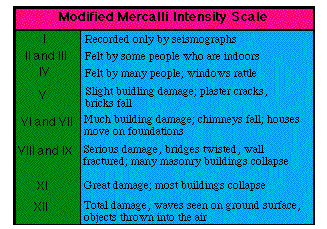
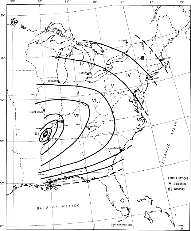
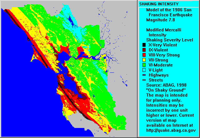
Strength of earthquakes can also be measured using the Modified Mercalli (MM) Intensity Scale, which is a qualitative scheme based on extent of damage. Because surface damage is most intense near the epicenter and generally decreases with distance, for any given earthquake this scale may vary widely with geographic location. For comparison, see the MM maps for the 1811-1812 New Madrid (MO)and the 1906 San Francisco (CA) earthquakes; the greater extent of MM zones for the former event reflects the greater crustal elasticity in the mid-continent and eastern US.
Seismic moment (Mo), defined as the product of [rock shear strength]*[surface area of faults]*[average displacement], is a more consistent measure of earthquake size (energy release) than is magnitude; a magnitude scale based on this parameter (Mw = 2/3*log[Mo] - 10.7) is now used widely as it shows near-linear variation with energy release. This measure can be used to predict such things as size of earthquake for a given fault geometry and displacement.
Distribution of Earthquakes
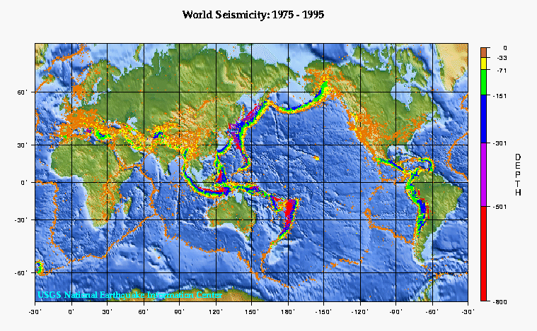
Global Seismicity
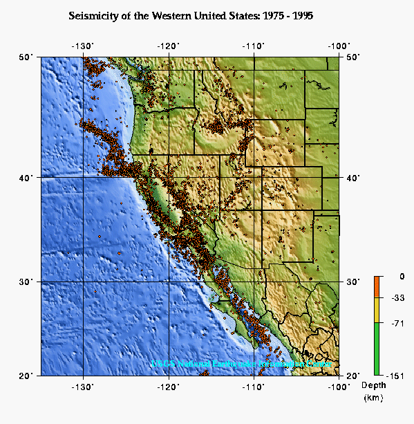
Seismicity in the United States
Seismicity and Plate Tectonics
Earthquake Case Studies
Seismicity associated with strike-slip faults
Seismicity associated with subduction zones
Seismicity associated with volcanoes
New developments in assessing earthquake deformation
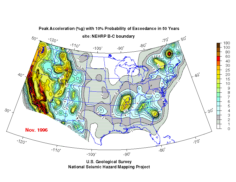
- Probability of earthquake occurence in the US can be estimated from a map of seismic peak acceleration. The scale indicates areal differences in intensity of ground motion.
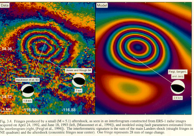
- Repeat satellite radar altimetry measurements, before and after an event, can be used to produce an interferometry image showing ground deformation (in this case, associated with the 1993 Landers (CA) earthquake). The color bands (fringes) correspond to multiples of about one inch of change in surface elevation, resulting from deformation associated with the earthquake.
- Analysis of three-dimensional distribution of hypocenters for the main shock and related aftershocks for an earthquake 'event' can produce a detailed fault zone image, in this case for the 1994 Northridge (CA) earthquake. Here, the fault plane did not actually break the ground surface; such 'blind thrust faults' beneath the Los Angeles basin account for some of the most damaging earthquakes.
Seismic tomography & 3-D imaging of subduction zones
The velocity structures of convergent margins have been imaged using the technique of seismic tomography - wherein arrivals of numerous seismic waves penetrating a study area are analyzed to determine relative velocity variations (anisotropy) in 3-D. Subducting oceanic lithosphere slabs (also defined by earthquake seismicity) are characterized by fast velocities, whereas portions of the upper plate (especially beneath volcanic arcs) have slow velocities that are attributed to ingress of slab-derived fluids, zones of partial melting, or magmatic conduits and reservoirs.
- Examples of such imagery are available for the back-arc Lau Basin, associated with the Tonga-Kermadec volcanic arc.
- Global tomographic inversions for a regionalized Earth model (RUM model) have produced 3-D images of several subducted slabs; global maps are also available showing the data sets on which these inversions are based.
Seismic Hazards
Risks due to earthquakes can be evaluated in terms of probability of events, likely magnitudes, and potential damage.
Main hazards include: ground motion, faulting and ground rupture, aftershocks, fires, landslides, liquifaction, changes in ground level, tsunamis, flooding.
Basic information on earthquake hazards
Hazards assessment
Study questions
Useful discussion and study and review questions can be found in such textbooks as Natural Disasters, P.L. Abbott (1996). You should also explore other WWW resources listed below and examine the EQ facts lists site.
To test your understanding of earthquake hazards, try to develop appropriate hazard mitigation plans for various real world stiuations (see below).
Also, try taking a Quiz to test your EQ sense.
Related web pages:
 LAST MODIFIED:
16 Feb 99
LAST MODIFIED:
16 Feb 99
BY: Bill Leeman