![]()
NAVIGATION & CARTOGRAPHY: A HISTORY FL*52802:300PM-05:30PM seed@rice.edu HIST 424 Prof. Patricia Seed
![]()
Navigation and cartography changed more rapidly in the period from 1400 to 1600 than in any other period prior to the 20th century. Both accurate elliptical projections and celestial navigation were invented in this period. Topics covered include the history of projections, origin of latitude and longitude scales, compass roses, ship design, the nautical astrolabe, and related subjects. A list of the subjects covered appears at Latitude.
![]()
Readings:
The Children of Noah: Jewish Seafaring in Ancient Times by Raphael Patai, James Hornell, and John M. LundquistThe Ancient Mariners : Seafarers and Sea Fighters of the Mediterranean in Ancient Times by Lionel Casson
Arab Seafaring in the Indian Ocean in Ancient and Early Medieval Times by George Hourani
When China Ruled the Seas: The Treasure Fleet of the Dragon Throne, 1405-1433 by Louise Levathes
Voyage of Rediscovery by Ben Finney
Flattening the Earth: Two Thousand Years of Map Projections by John P. Snyder
![]()
Week 1: Introduction
The course follows a spatial trajectory, beginning with the world's largest ocean, the Pacific, then the Atlantic (including its inland seas, the Mediterranean and Arctic), the Indian, and finally the Southern Ocean.
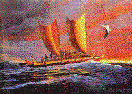
Week 2: Navigating Elsewhere I: The Pacific Polynesia and Micronesia: Crossing 1200 miles of Open Ocean 800 C.E. Voyage of Rediscovery by Ben Finney
Week 3: Navigation and Cartography : The Myth of Mediterranean Origins
The Ancient Mariners : Seafarers and Sea Fighters of the Mediterranean in Ancient Times Lionel, Casson
Week 4: Navigation and Cartography: The Myth of Mediterranean Origins Part II: Jewish and Arab Seafaring in the Mediterranean
The Children of Noah: Jewish Seafaring in Ancient Times by Raphael Patai, James Hornell, John M. Lundquist (required)Recommended: Christophe Picard La mer et les musulmans d'occident au moyen age Viie-Xiiie siècle (Paris, 1997)
Week 5: Navigating Elsewhere II: The Origin of Modern Oceanography, Meteorology, and Terrestrial Magnetism: The South Atlantic
See Latitude Website, especially on Magnetism
Week 6: The Technologies of Space and Place, I: Latitude
The Invention of the Astrolabe and Scientific Calculation of Latitude 1471 C.E. (Or, don't believe everything you read in popular science)Optional: Seed, Ceremonies of Possession chap. 4
Week 7: The Technologies of Space and Place, II Cartography What are Projections and How do They Work?
Flattening the Earth: Two Thousand Years of Map Projections by John P. Snyder
Week 8: The Technologies of Space and Place, III
Cartography Practicum GIS & GPS How do these compare to techniques circa 1500?
Week 9: Latitude: The Technologies of Space and Place, III
The Origins of Contemporary Cartography and the first Accurate Elliptical Projections (Hint: 1502)
Week 10: Navigating Elsewhere III: The Indian Ocean: Navigating by Poetry and by Monsoon 850 C.E
Arab Seafaring in the Indian Ocean in Ancient and Early Medieval Times by George Hourani
Week 11: Navigating Elsewhere IV: The South China Sea: Using the Continental Shelf
When China Ruled the Seas: The Treasure Fleet of the Dragon Throne, 1405-1433 Louise Levathes
Week 12: Navigating Elsewhere V: The Southern Ocean :Rough Seas From South Island to Tierra del Fuego
"Below forty degrees south there is no law; below fifty degrees south there is no God."Recommended: Fatal Storm: The Inside Story of the Tragic Sydney-Hobart Race by Rob Mundle
Week 13: The Original Fixing of Longitude and Magellan's Voyage
Fernão Magalhães (Magellan) Ruy Faleiro, Francisco Faleiro
Week 14: Mapping Oceans The inverted topography of depths
![]()
Requirements:
Acquire a basic understanding of GIS (instruction in week 7) (15%)
There are two options for all the other assignments:a history option and an art/geography option.
History option: Written (2-3) page reports on each of the five books .
Art/Geography option: an original image (psd, gif, or jpeg) on the subject of the book, or an original projection or map of the voyage described.
Final project: History option: 15 page written paper on any of the subjects in the course; Art/Geography option: web pages (7) on the subject of the course OR original map or globe projection of the features of one of the oceans studied.