History of Navigation and Cartography
Hist 424
Patricia Seed
Class meets Wednesday (section 2) and Thursday (section
1) evenings from 7-10 P.M.
![]()
Class meets Wednesday (section 2) and Thursday (section
1) evenings from 7-10 P.M.
![]()
This course will cover everything you have EVER wanted to know about shipping lanes, their history, mapping, and sailing. (How former students use this class)
Why shipping lanes? In the first place, they are the major means of transport of international trade. Currently 85 percent of all goods travel by ship to their destination. While high-speed connections have revolutionized the transfer of capital and information, improvements in shipping have revolutionized the world's trade in goods.
When did contemporary shipping lanes begin? Who discovered them? Why the discovery of shipping lanes was the first modern intellectual property claim. How did we get to the system of shipping lanes we have today? How do current aeronautical and nautical lanes differ?
Week 1 Introduction Tour the Website; Living in a Portuguese Castle; Planning & Explaining
Week 2 (Sept. 4 or 5) The origin and discover of modern shipping lanes. (Hint: It has something to do with the first week of class. & Magalhães.)
Sites of the night:The Modern Routes, Magellan's routes, Heroin Trade Routes (Source: DEA) , Early Southeast Asian routes,
Early Afro-Euro-Asian Routes: Roman ships, Roman-India trade in 1st Century, Maritime Version of Roman-Eygpt Trade Archeology of the Euro-Asia Trade,
Intra-African Trade Islam and West African Trade, Gold-Salt Trade
Old World Trade Routes (only a few maritime ones) good for food presentations, Check out Asian shipping routes
Weak 3 Former US Maritime Commissioner (and Rice grad) Rob Quartel talks about freight and contemporary shipping lanes. Thursday evening only! Attending is good career move
Sites of the night:FreightDesk , Overview of Freight Industry (Requires Adobe Acrobat)
Week 4 (Sept. 18 or 19) :Just the facts, Ma'm. The Basics of Celestial Navigation Tryout several handheld astronomy programs (class in the courtyard) Examples include CelestNav, 33 Knots, Tide Tool, GeoMagInfo, Sidereal Time, Astro-matics and a variety of other interesting navigational programs. Recommended reading: The Figure 8 on Star Maps
Week 5 (Sept. 24 or 25) The BEST Traditional Celestial Navigators Polynesia and Micronesia See me on board the Hawaiki in Honolulu. Rapa Nui Voyage Turn in project on celestial navigation
More detail: Tides and Currents
Week 6: (Oct. 2 or 3) The GIS Lab Learn Basic ArcMap 8.1 You get 15% of an A just for attending. Medical Effects and Chemical Uses of Hazardous Materials
Turn in project on Polynesian navigators
Week 7 (Oct, 9 or 10) Doing GIS backwards--using it to find scale, projections, etc. The Portuguese shipping lanes and the origin of scientific cartography
Week 8 Tour Port of Houston; maybe climb the stairs of a container ship.
Week 9 (Oct. 23 or 24) The merely good traditional navigators & early shipping lanes: Chinese, NW Indian Ocean, What's wrong with Gavin Menzies' ideas?.(His book comes out in November.)
More detail: Weather for Dummies, National Audubon Society, Field Guide to Weather
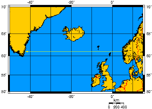
Week 10 (Oct. 30 or 31) Vikings & the so-called Vinland map. Track Viking ships; make sunstone compasses
More detail: Voyage from Iceland. Titanic, icebergs, & Harry Widener Turn in Project on Chinese/NW Indian Ocean or do Viking project for the following week. (If you are Halloweening, please show up on Wednesday instead.) Ghostly Lighthouse Tales
Week 11 (Nov. 6 or 7) The True History of Terrestrial Magnetism (it's all about the map) and the Invention of the Astrolabe (celestial navigation)Additional information: Basic Information on the Earth's Magnetism; Where is the difference between magnetic north and true north the greatest? (in blue); Find Magnet declination for anywhere on earth in the last decade; See minute to minute changes in magnetism as recorded for the last twelve hours
Picture of a magnetic storm (NASA slinky); Historic changes 1841-1960 measure in Boulder, Colorado, Moscow, Kyoto, Copenhagen, Edinburgh, Bombay
Turn in Viking project if you did not turn in Project on Chinese/NW Indian Ocean last week.
November 11 2 P.M. Watch our own Chuck Clark on Weakest Link Sorry Chuck!
Week 12 (Nov. 13 or 14) Latitude (or why I hate Dava Sobel's book) and the Truth about the First Prime Meridian (or how I changed the narrative of England's National Maritime Museum & the Greenwich Observatory)
Week 13 (Nov. 20 or 21) Mess around with Maps, Old Time Ships CD (in class) Ship models and images, Learn Basic Web Design, rehearse final project
For the interested attend GIS day(Nov. 27) Teacher's Location
Week 14 (Dec. 4 or 5) Starry Night or other mapping or geography/computer game (class designed for tired students and jet-lagged faculty) Final Food Projects must be prepared Wednesday or Thursday!
Requirements:
Basic GIS: How can you understand contemporary mapping if you can't do GIS? Simple. You can't. While not everyone will become a GIS expert or even be fluent in it, everyone needs to u>understand 1) What a GIS system is (and what it isn't) 2) The difference between projection and a coordinate system. 15 % of final grade.
GIS to understand change over time. Currently one of the hottest topics in GIS. One or more the leaders in this area will be talking to the class, hopefully.
There are three options for all the other assignments: a history/literary option, an art/geography option and new this semester, a food option. (Each is 15%)
History/literary option: Written (2-3) page reports, on the projects for weeks 4, 5, and either 9 OR 10
Art/Geography option: an original image (psd, gif, or jpeg) on the subject of the book, or an original projection or map of the voyage described.. Projects for weeks 4, 5, and either 9 OR 10 .
Food option. The diffusion of food (via shipping lanes) or food on board ship. (Warning: I hate poi.)
Final project: 40% Due last day of finals, December 18th.. History option: 15 page written paper on any of the subjects in the course; Art option: web pages (7) on the subject of the course OR Geography option: original map or globe projection of the features of one of the oceans studied. Plus there is also a new Food option based on either the diffusion of food (shipping) or food on board ship.