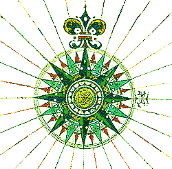
CHARTING A COURSE WITH A COMPASS

Meant using a compass drawn on the chart (called a compass rose). Portuguese map-maker Pedro Reinel drew the first now-standard 32 point compass rose with the fleur-de-lis indicating north and the cross east (toward the Holy Land). See where Reinel's son Jorge drew the compass rose on the black and white version (below) of his nautical chart.

Move your computer's mouse over the compass lines to see the numerical values (and sailing directions) for each course (displayed in status bar below). See how much easier it is to distinguish numerically small differences (101.25 and 112.5) in directions when the differences are displayed with triangles of opposing colors.
See how easy it would be to make a mistake (and get lost at sea) using the traditional Mediterranean line compass from 1440.

Reinel began the tradition of drawing the large compass rose on West Africa, allowing pilots to plot courses in either the North or South Atlantic Oceans. Knowledge of the African interior of Africa (roughly at the Sahara) was also likely deemed less important.

Details of the compass directions|  More Compass Roses | Map-Making: A Guide to Sources on the Internet | Reinel Map Features | Home page