![]()
Traditional Navigation
Traditional Navigation
Using the North Atlantic Coastal Shelf
![]()
|
|
Traditional Navigation
|
|
 |
When the first Viking caught sight of Vinland (Canada) by accident circa 986, he was unable to land there. Using information from this first accidental voyage, Leif Ericson reached Canada fourteen years later. Sailing in the summer--with the midnight sun--and guided by the pole star, Leif reached what we now know as the coast of Canada. Ericson did not have a compass, but it would have been useless in these northern latitudes where magnetic deviation is very large. |
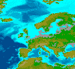 |
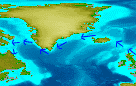
For centuries, Northern European sailors, like Leif, reached North America by sailing along the northern rim of the Atlantic guided by the high continental shelf ( where the sea bottom is shallow shown here in light blue).. Further to the south in Europe, sailors cruising the Mediterranean were also seldom more than a day away from sight of land, making them just as coastal as their northern brethern. |
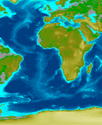 |
As coastal navigators, Europeans did not venture into the middle of the North Atlantic because they had no continental shelf.to follow. (See the difference between the generous continental shelf around Great Britain and Scandinavia (left and above) and the slender western coast around Africa.) Furthermore, because of winds and currents, the continental shelf was impossible to follow on Africa beyond a place called the Bulging Cape (Cabo Bojador). Therefore before 1400 there existed no European tradition of high seas navigation because the middle North and South Atlantic oceans were too difficult to sail using any type of traditional knowledge. |
Available Elsewhere on the NetWhat is a continental shelf?Icelanders recreate Early Voyages to the New World Texts About Voyages || Short Account || Drawing of Viking Sun Compass || Viking's Sunstone(how they used the sun) || Viking Ship Museum at Roskilde (in Danish only) |
|
![]()